1922 Mohawk Trail Postcard Early Automobile Map Back New Route North Adams Mass
Description
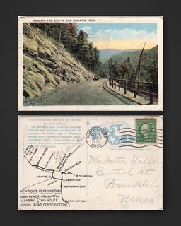
Front: "Nearing the End of the Mohawk Trail": an early automobile on the mountain road beside a rock cut, with a wooden guard rail and the valley beyond, in color.
Back: A printed map back: "The Mohawk Trail. The Berkshire Hills are seen at their best from this most wonderful scenic highway. It traverses the Hoosac range of Mountains between North Adams and Charlemont, Mass." The map shows North Adams, Charlemont, Greenfield, Northampton and Springfield: "New Route Reaching Trail. Good Roads - Delightful Scenery [This Route Avoids Road Construction]". No. 101436. 1-cent green Washington stamp, North Adams, Mass. machine postmark, Oct 5, 12:30 PM, 1922.
Pencil address to Mr. Walter Hills, Central St., Franklin, Mass. The Mohawk Trail opened to cars in 1914 as New England's first official scenic tourist route.
Size approx. 5.50 x 3.60 in.
Read the full description
Condition
Light wear. Please study the images; they are part of the description.
Provenance
From my family's estate collections, built over more than 60 years by knowledgeable antiques collectors and traders. Stored in a climate-controlled environment.
Disclaimer
The images and any video show the actual item and are part of the official listing description, so please review them closely. Measurements and weights are approximate, and any maker or material we haven't confirmed is described as assumed. Questions? Message us; we answer quickly.